Thank The Bay of Fires for the Tasmania we know
Posted on
Keeping Tasmania warm in more than one way
Tasmania could have been a lot colder than you think! And we can thank these unassuming rocks for keeping Tasmania in our Australia.
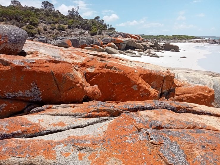
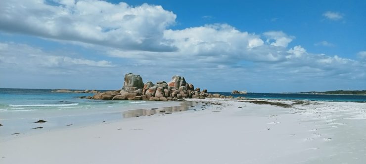
When people think of the Bay of Fires, they mostly picture the lichen-covered rocks that feature all along the coastline, from Wineglass Bay to the north-eastern corner of Tasmania. The vivid orange of the lichen is one of the main attractions, but the rock it covers – Devonian granite – actually has a fascinating story. It is why when you visit Tasmania, the land you are standing on is part of Australia, and not way further south – in Antarctica!
Tasmania, a geologist’s wonderland
Everyone who has had the pleasure to visit Tasmania knows the island state is a candy store of geological wonders, from the Tarn Shelf of Mt Field National Park, the towering peaks of its central Cradle Mountain, painted cliffs of Maria Island to the spectacular dolomite cliffs of Cape Raoul and Cape Hauy; everywhere you turn, Tasmania’s geology is on full unabashed display.
And you can thank Tasmania’s unique geo-geography for a wild and wondrous world of diverse plant and animal life, making it a true paradise and drawing in nature walking enthusiasts from all over the world.
It’s strange to imagine that 70 million years ago, Tasmania was nothing like the island we know today.
Luckily for us over eons of geologic shifts and movements, it emerged as a stunning landmass to the south of the Australian mainland. We swapped a partly submerged landmass filled with dinosaurs for Tasmanian Devils, probably for the better.
So what do the iconic Bay of Fires have to do with it?
From beautiful beaches of pristine white sands and turquoise waters to the breathtaking landscapes, the Bay of Fires is a stunning natural wonder that will take your breath away. Rich in history, culture, and flora and fauna to boot.
However, we think the most interesting thing about the area is the granite rock underneath, not the orange lichen covering it, which is generally what people picture when they think of the Bay of Fires. This granite is what ‘attached’ Tasmania to the mainland when Gondwana broke up, and Australia was rifting north off Antarctica. Otherwise, Tasmania would have remained attached to Antarctica, and life would be different in Tasmania right now – a bit cold for one thing!
A little more about the Bay of Fires
The name Bay of Fires comes from Captain Tobias Furneaux, who in 1773 saw the fires of Aboriginal people burning along the coast as he sailed past. The region has been home to the Palawa people for thousands of years, and the area holds deep cultural significance. Middens, artefacts, and stories remain as reminders of this long connection to the land and sea.
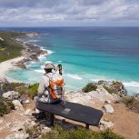
Today, the Bay of Fires is celebrated as one of Tasmania’s best walking destinations. The Bay of Fires Lodge Walk and other guided experiences allow visitors to explore the coastline’s hidden coves, sand dunes, and headlands over multiple days. Even shorter day walks offer access to secluded beaches, tidal pools, and vantage points perfect for spotting dolphins, sea eagles, and migrating whales between May and November.
The area is also known for its biodiversity. Behind the beaches, you’ll find coastal heathlands, wildflowers, and birdlife unique to Tasmania. Marine life thrives in the clear waters too, with snorkelling and kayaking revealing another side to this wilderness. For many visitors, the contrast between the fiery rocks, turquoise seas, and lush green vegetation makes the Bay of Fires unlike anywhere else in Australia.
Accessibility is another drawcard. Located about a three-hour drive from Launceston, the Bay of Fires is remote enough to feel wild, yet close enough to fit into a Tasmanian road trip itinerary. Visitors often combine time here with nearby attractions like Mount William National Park or Freycinet National Park to experience more of the island’s spectacular east coast.
The Bass Strait
This stretch consists of two bands of islands, from the northern corners of Tasmania to the mainland, Victoria.
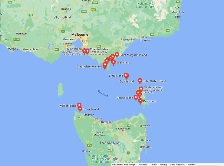
This stretch of water is one of the most dangerous and unforgiving in the world! Stretching 250 kilometres but home to over 50 islands (including Flinders Island & King Island), there are 600 shipwrecks on the Victorian coast alone. It was common for sailors to describe crossing Bass Strait as ‘threading the eye of the needle’.
A strong grip hundreds of kilometres long
The amazing thing about the Bass Strait is that a sedimentary basin in the middle was created as a kind of pre-rift stretch-mark. As the rift moved from NNE to SSW along what is now the Great Australian Bight, the earth’s crust started to move fractionally between future-Victoria and future-Tasmania, creating the Bass Strait basin. The Bass Strait islands, and other coastal outcroppings like the Bay of Fires, are the surface tips of the granite bands, which extend several kilometres down.
These rocks are the surface tip of a granite band kilometres deep, running between north-eastern Tasmania and Victoria, with a matching band on the western side of Tasmania. The rock boffins (AKA geologists) think that during the break-up of Gondwana, the rift opening up the Southern Ocean from off the coast of WA, splitting Australia and Antarctica, was running in an easterly direction and set to cross somewhere in the vicinity of where Bass Strait is now. But these granite bands held the land together, and forced the rift to turn south and go around the bottom of proto-Tasmania. So Tassie is heading north with future-sunny mainland Australia, rather than staying attached to freezing cold Antarctica.
‘Maybe we should see other landmasses’
The separation of Australia from Antarctica happened last (long after India, Africa and South America had all left), starting around 130 MYA and finishing around 80 MYA when Australia finally started drifting north (with Tasmania in tow!).
The granite bands are one of the reasons geologists think it took so long – the bands created a zone of greater adhesion, which turned the easterly running rift to the south.
Imagine standing in Antarctica, surrounded by blinding white snow and ice, buffeted by freezing winds, next to penguins and seals?
Join us exploring Tasmania’s geological wonders
Rock boffin or not, it’s impossible not to appreciate its many geological formations, and now even more so! You can’t turn a step without finding fascinating evidence of the shape and direction of our continental history. Take a trip to the Bay of Fires with us, and you can see firsthand how these fiery orange granite rocks have played such an integral role in the making of our amazing island state today.
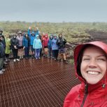
I’ve been guiding tours across Australia for over 20 years — from Kakadu to the Kimberley, Tasmania to Arnhem Land. Whether it’s sharing ancient stories, spotting wildlife, or walking through rugged landscapes, I’m passionate about helping travellers connect with Country.